Located 15 km north of Ampara, Rajagala, or Rassagala, is nothing but a blip on the tourist map of Sri Lanka. The ruins of a 3 BC monastery complex are still being reclaimed from the thick jungle by archaeologists, bits of buildings and stupas meticulously excavated and puzzled together to reveal what was once a huge site with hundreds of buildings and stupas atop a hill, second only to Mihintale in Anuradhapura.
The legend goes that people of the Raksha tribe, worshipping the Rakshasas - mythological demons, lived there. Over time the word "Raksha" became "Rassa", hence the name Rassagala - Demon's mountain. Later, as the monastery complex was developed under the rule of the Anuradhapura kings, starting in 2 BC, the name changed to Rajagala - The King's Rock.
The history of the place is not clear, there are a big number of drip-ledge caves that were probably used as early as 3 BC by Buddhist monks. Rajagala is only one of two places in Sri Lanka that has an inscription mentioning Arahath Mahinda Thero - the monk who brought Buddhism to the country, some even think this was his burial spot, which would confirm that there was a working monastery or hermitage here at that time. But even further than that, there are caves with Vedda writings or petroglyphs, which would indicate that people were present at this hill even in pre-Buddhist times.
We found very little information about Rajagala online - in several places it was mentioned that it is a huge site, but we were not sure whether it was possible to visit at all or what exactly we would be able to see there.
There are two reasons for the lack of information and conflicting reports. First, it is very much off the tourist track, both for local travellers and even more for international visitors, and second, archaeologists are currently digging up the place and had started with it just few years back in 2015. There were reports online about jungle treks, very few excavated buildings and need for guides, but when we visited (August 2020) things had apparently developed quite a bit, and there were restored, well-established paths, a lot of buildings on top are unearthed, and the whole site can easily be walked on your own in about 4-5 hours.
If you want to visit the site, a trek of the whole place is around 10 km, which took us 5 hours with all the stops for taking pictures, exploring, resting and taking in the atmosphere. It can be cut short by just visiting the main zone, but still, you will need 2-3 hours. There is a steep hike up at the start, that took us around 40 minutes.
Make sure you take enough water with you, there are no vendors and no drinkable water on site. At least 1l - 1.5l per person.
At the guard booth at the car parking, we were shown a map and we could take a picture to use. The original map is Sinhalese, here is a copy of it, I have marked it in English - download high-resolution version from here.
Our day at Rassagala
We arrived at the car park around 9, and as is the way with everything in Sri Lanka - better to start early to take advantage of the morning fresh air.
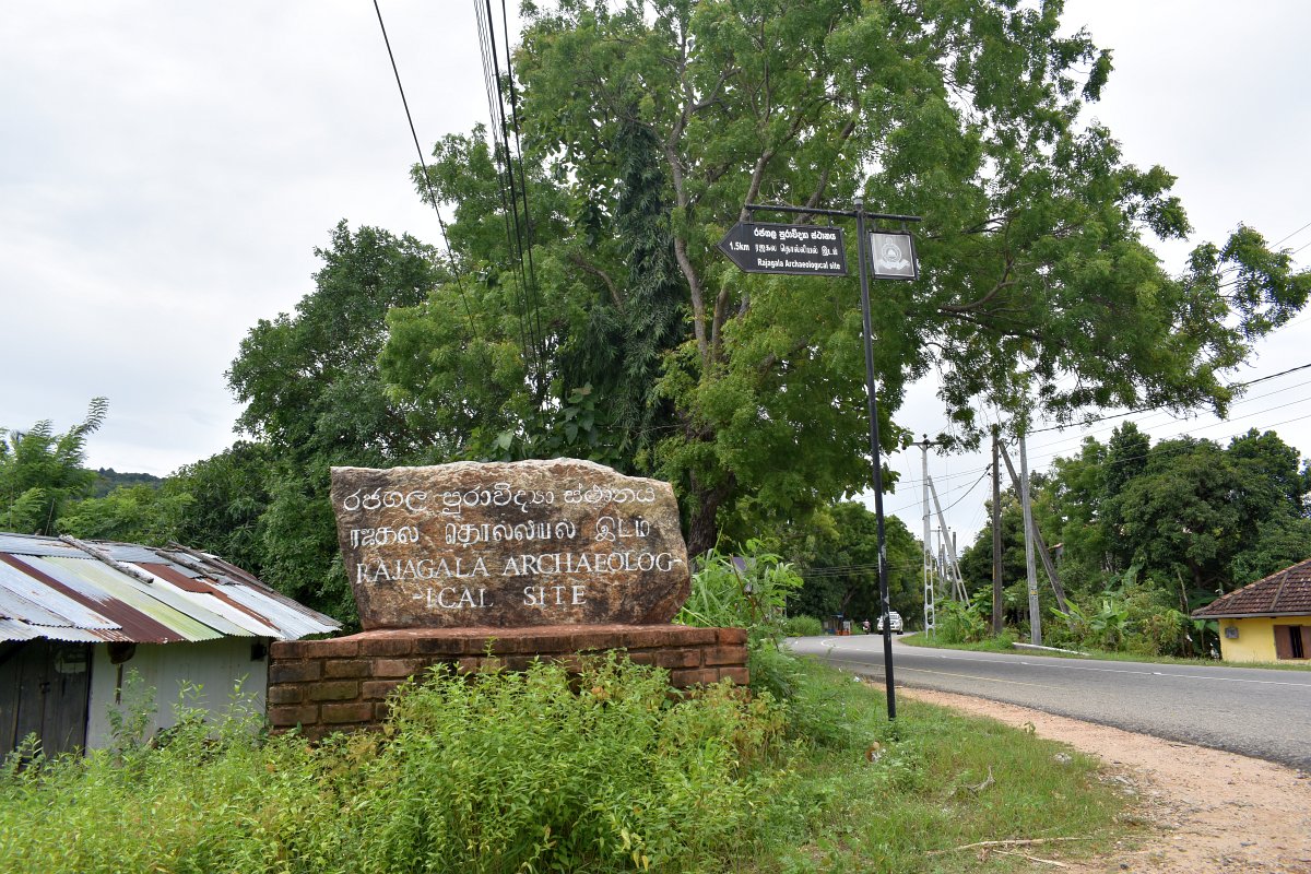
At the moment, there are 3 points in Google maps - "Rajagalathanna Car Park - Section A", "Rajagalathanna Car Park - Section B" and "Rajagalathanna Car Park - Section C" and the path starts at parking A. If coming from Ampara there is a sign pointing to Rassagala Archaeological site a short distance after passing through the town centre, Google tried to navigate us through some inner streets before that - they are in awful condition, best is to look for the sign and follow that road.
The car park was brand new, just a couple of other cars there except us. The path started on one side and there was a guard booth, that would probably turn into a ticket booth at some point, but when we visited we only signed the guest book.
They had a map we could take a picture of - everything was in Sinhalese only, but still, it was great to have a map and this made it so much easier to go around the whole site. As it is an active archaeological dig, the map was not 100% up to date, there were some more buildings already cleared up. Get our translation of the map here.
The people at the booth tried to help us with the map, pointing some of the places, but their English was not great. It turned out one of them was a guide and he very reluctantly offered his services, probably worried he wouldn't be able to communicate well with us. We declined the offer and he seemed relieved. Opting to do it on our own was definitely the right choice, exploring the place at our own pace was a nice experience and in combination with the Sinhalese map there were enough signs in English to help us around.
The guard and the guide made sure to warn us that it is a 10 km trek to go around the whole site and it takes 4-5 hours, but we had the whole day planned for this visit and were prepared with enough water and comfortable shoes, so that was not an issue.
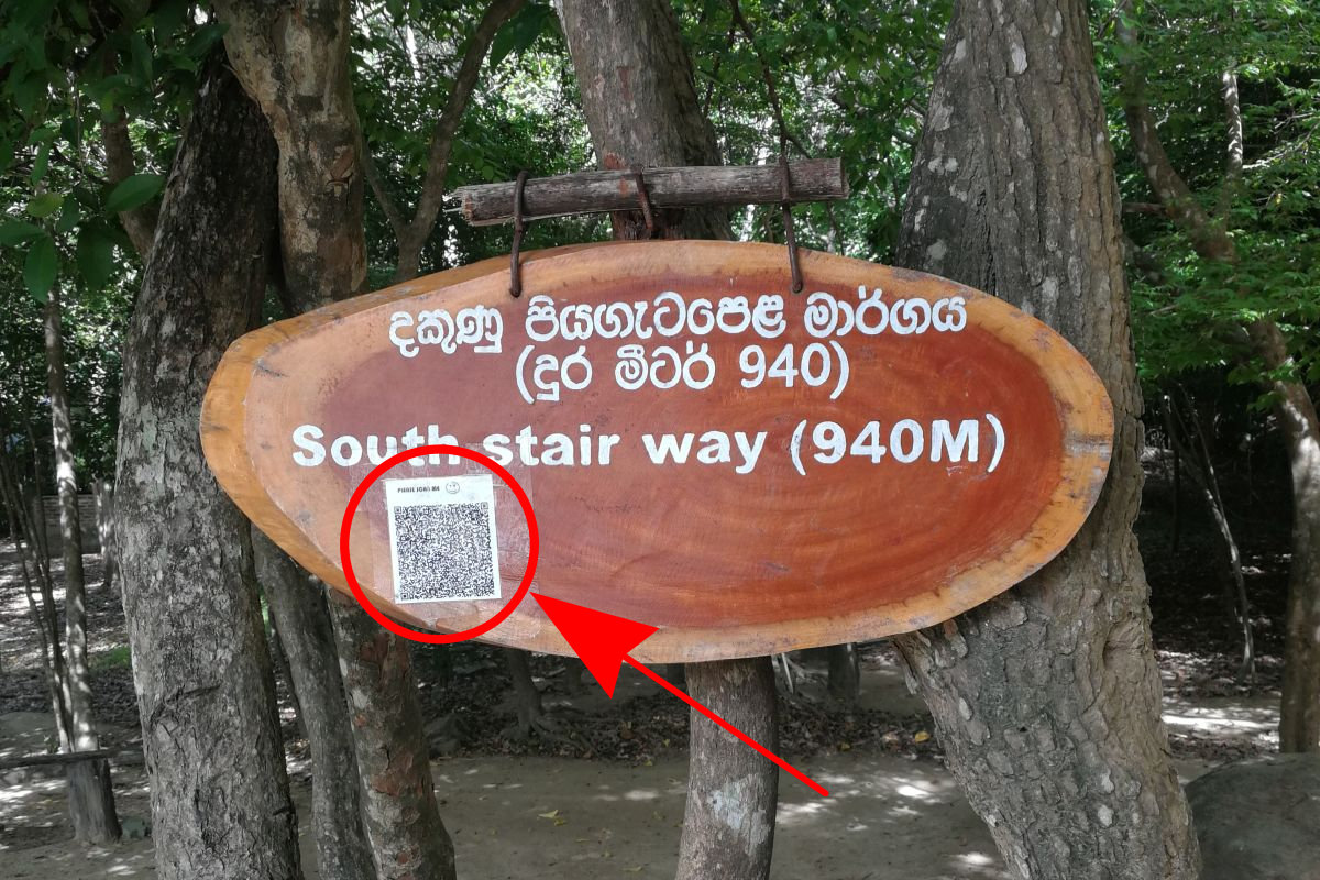
A lot of the sights had signed with names or building types, both in English and Sinhalese. In addition, there were stickers with QR codes that said "Scan me", which at first we discarded as some kind of spam. But the further up we went, the QR codes were still on most signs and we started wondering how dedicated this spammer would have been to climb the steep hill barely visited by anyone just to advertise something? So, sweaty and out of breath, we scanned one to see what the deal was. It turned out they were actually part of the signs - the QR code scans to a text in both English and Sinhalese with more detailed explanations of what you are seeing. Very handy!
The way up
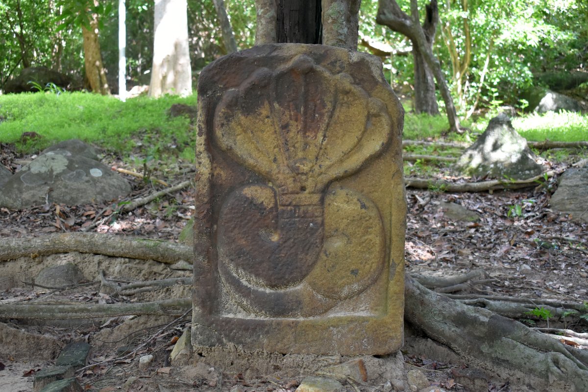
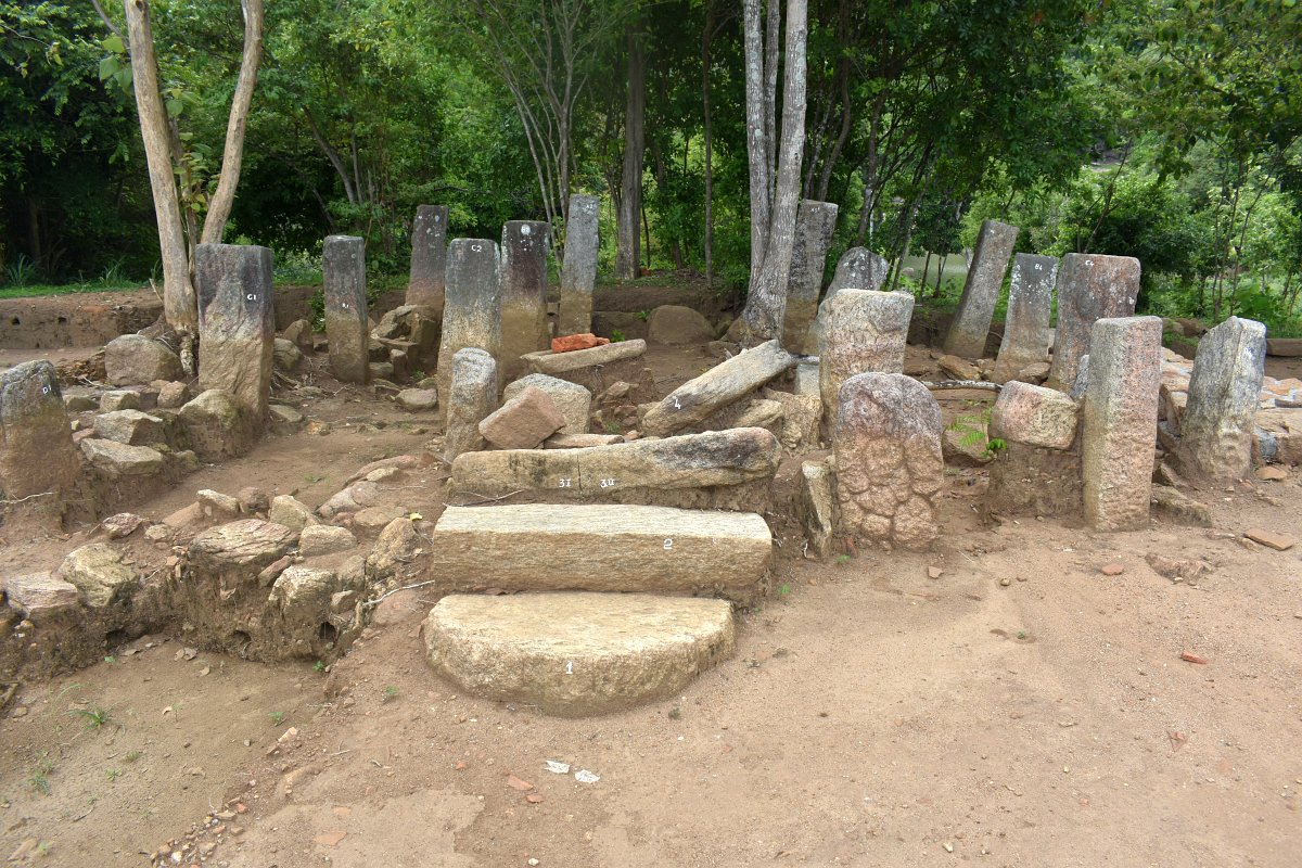
Shortly after starting along the trail, in a small flat area, we reached an open-air museum of sorts. Several carved rocks found in the forest were arranged for viewing. There was a grinding stone, half of a very detailed big guard stone, five-headed naga and some others, worth spending several minutes to have a look.
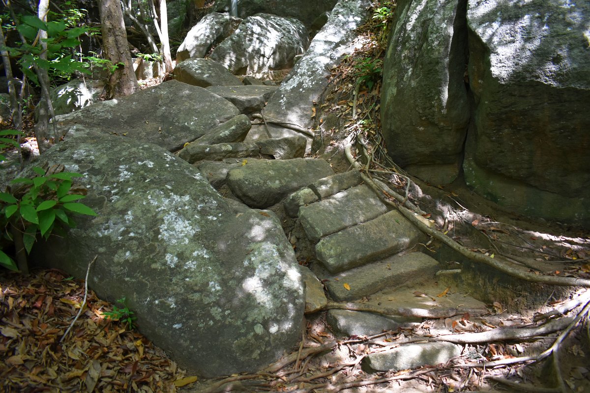
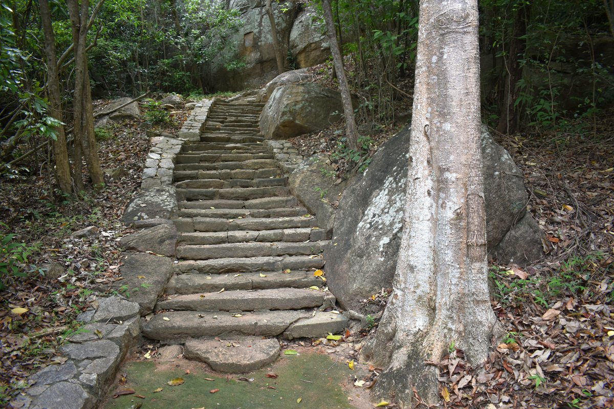
The path uphill was along the Southern ancient stairway, the stairs scattered in the earth, but the rectangular-shaped rocks still unmistakably recognizable. It was around 40 minutes hike up through the forest, a bit of an effort, but the shade of the trees the whole way made it easier.
Mahinda's stupa and the pond
Once at the top, the forest clears and the ancient site spreads ahead, a man-made pond with stepped stone walls and remnants of buildings. There are two designated major zones - zone 1 being the first dig, and main one, zone 2, on top of the hill where works were still done. Then further than that is the zone with the drip-ledge caves, which is completely covered by the forest.
The path goes left of the Mahinda's stupa first - there is not much left of it now - a bunch of brick-shaped stones sit in a mound-like pile. At the moment there haven't been any excavations done to confirm that the legendary monk is indeed buried here. A bit after that there is an ancient inscription in the rock face.
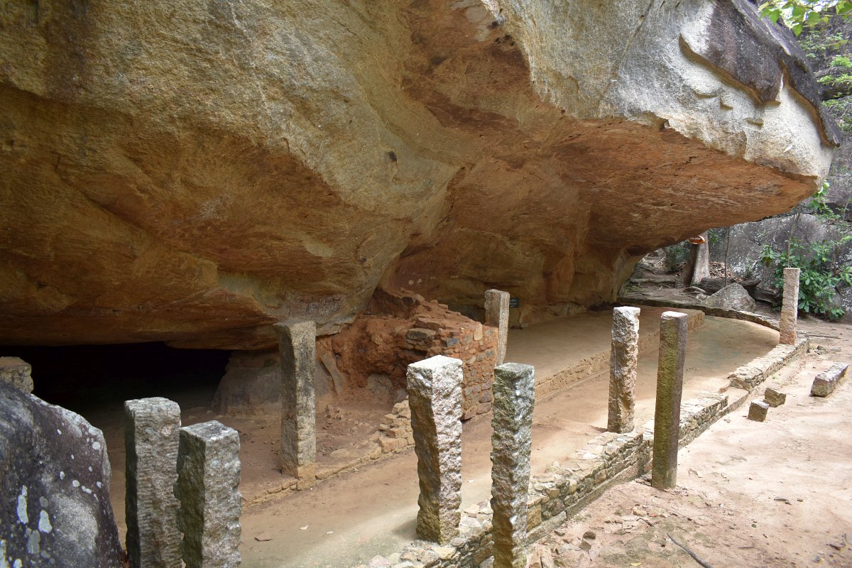
A short detour on the right after the inscription lead to a curiously shaped drip-ledge cave - the huge stone protrudes in the centre, a pillar-like portion supporting its weight and forming an umbrella-shaped shelter, giving it the name Umbrella cave. There are a few drip-ledge caves around this one and several more across the pond from it, but the major group of caves, numbering 130, is located a bit further up the way.
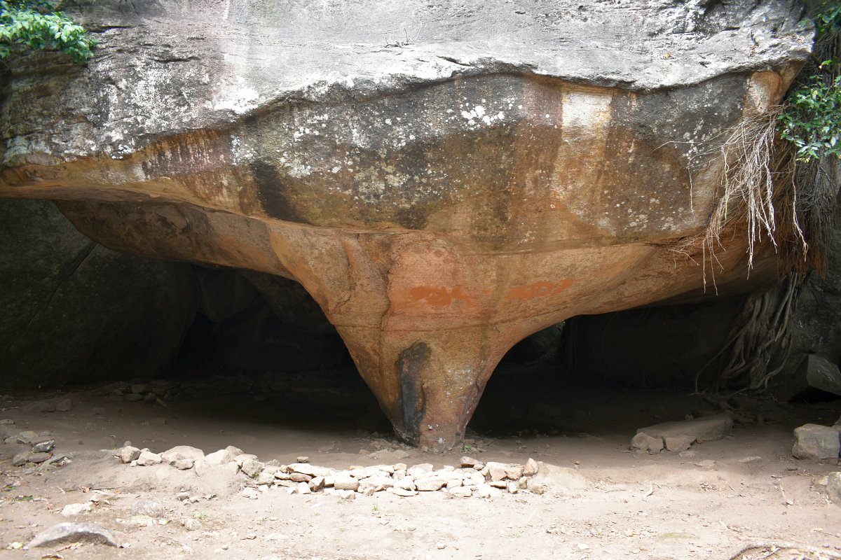
The drip-ledge caves are characteristic of the Buddhist temples in Sri Lanka during the Anuradhapura and Polonnaruwa periods, and even until today. Niches in the stones and between huge boulders are cleared and an edge is carved along the front of the cave - it prevents the water from sliding along the rock, instead it drips to the ground from the edge, providing dry shelter inside of the cave. Sometimes walls of stone, bricks or mud were erected to form a full building under the rock. Those caves were used, and some still are, by Buddhist monks as living quarters or meditation spaces.
After the Umbrella cave, the path goes around the pond and to a small shaded rest area, the main path continues straight, but we veered to the left and up the stairs at this junction to have a look at the group of buildings a bit higher on the hill - zone 2 of the archaeological site.
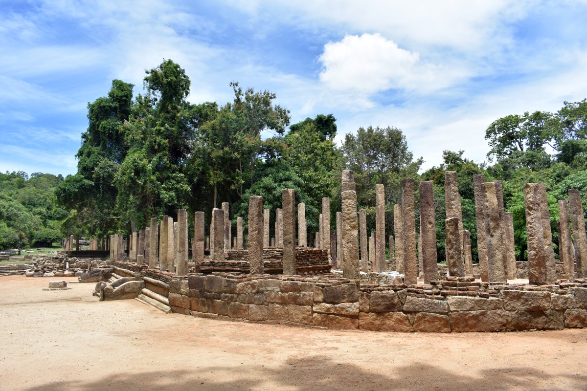
Zone 2
When we visited in August 2020, some of the buildings were still half-way excavated, and some were being restored. The map we were given at the foot of the hill was missing some of the newly excavated plots. The progress of the work is quite impressive, especially taking into consideration the exploration started just few years back - in 2015.
On top on the hill, the foundations of 5 buildings and 1 stupa were visible. The balustrades and stairs are very well preserved, as well as the stone floors, columns, moonstones and guard stones. Bigger and smaller pieces of roof tiles are sprinkled on the ground, a reminder that the bare skeletons of the buildings in front of us now, were once covered with solid roofs.
Immediately after climbing the steps, on the right, were a couple of buildings, their stairs and the moonstones in disarray, the floors inside - an uneven mess, and balustrades laying flat. Those buildings had been recently uncovered and not yet properly puzzled together to restore and preserve them better. A very interesting sight, showing how the archaeological process works.
On the left of the path were two image houses. One round, positioned on a square platform, with beautifully carved guard stones beside the entrance. The other one was a bit smaller, the stone where the central statue had been still standing in place, empty, the statue itself no longer there.
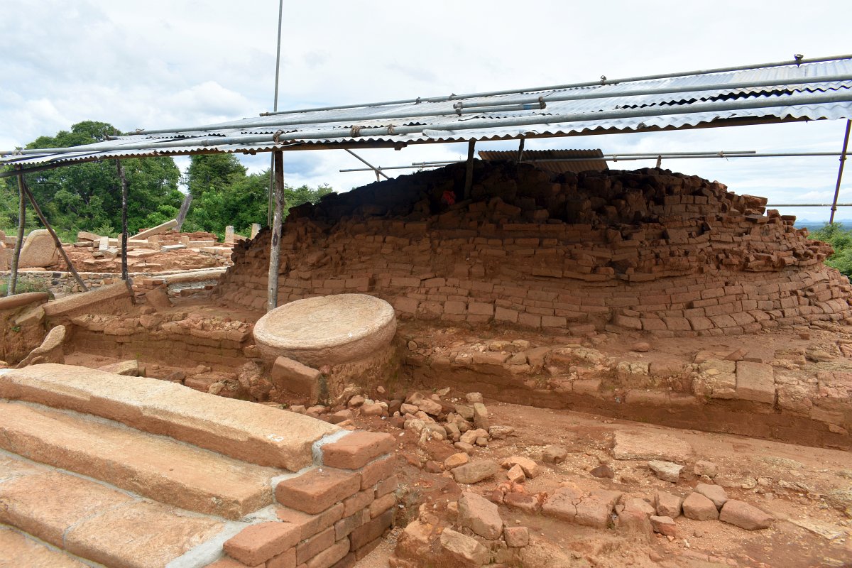
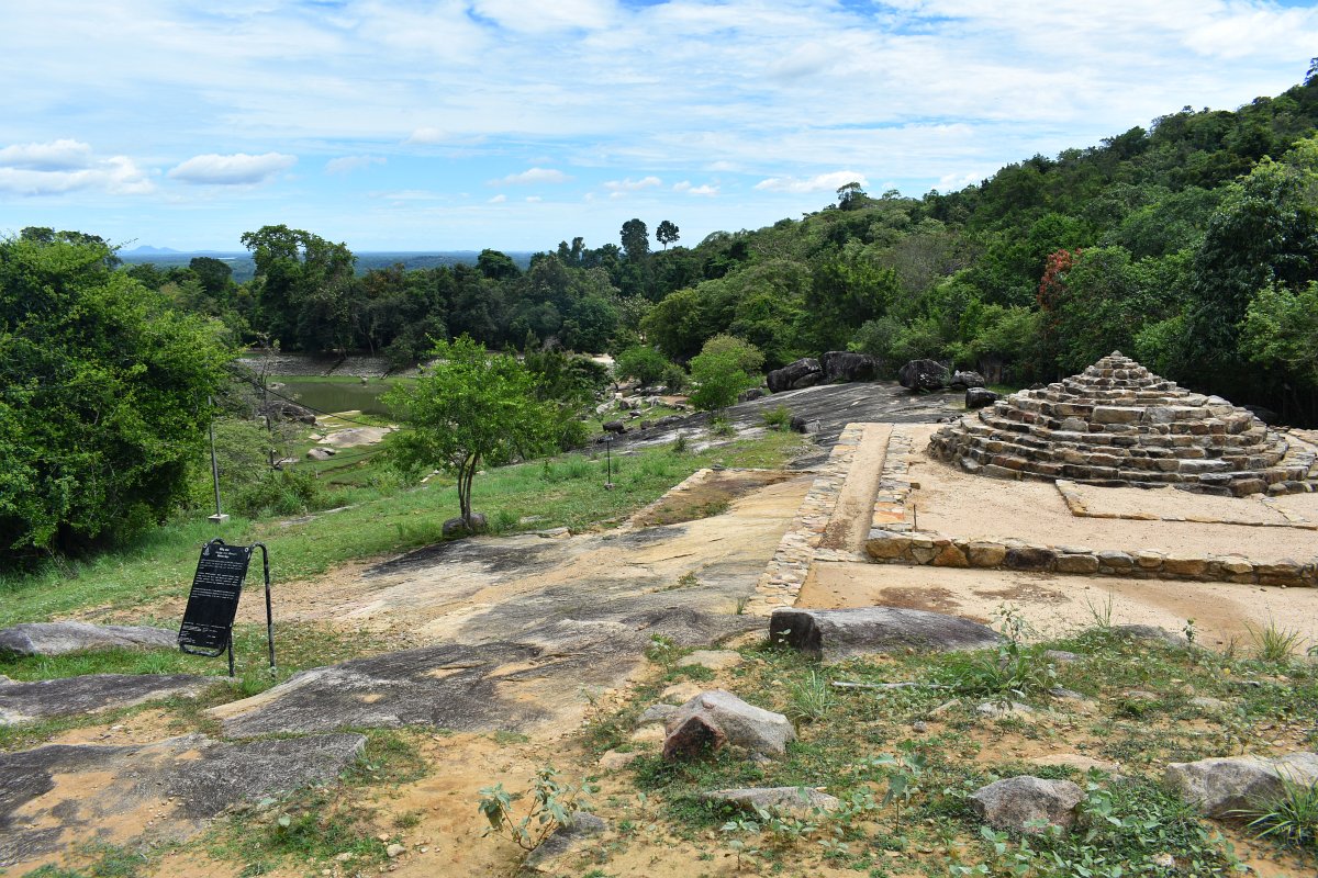
Further, a small stupa, with an altar was half-way restored. The centuries underground had warped the shape of the brick structure a little, but it was very much recognizable. No trace was left of the plaster that probably covered it at some point, but the bricks were still keeping strong.
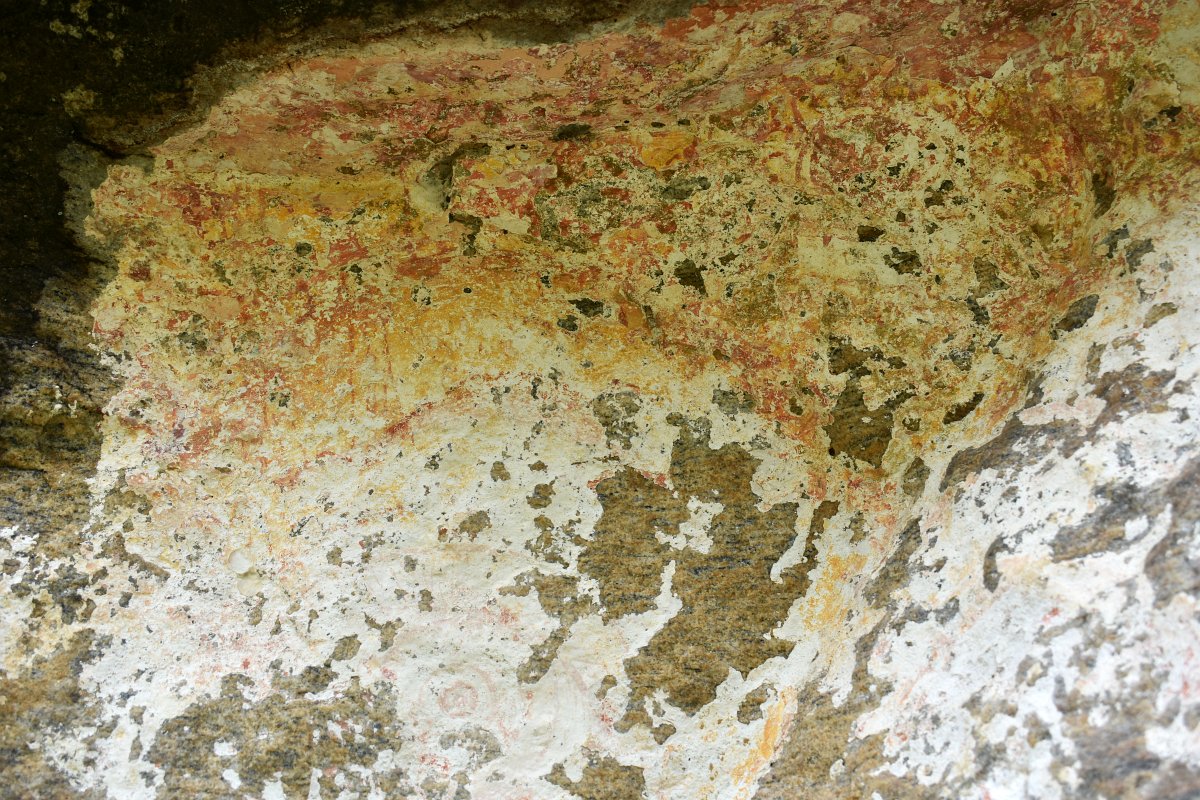
To get to the main site we went back to the pond and headed to the next clearing in the forest. Along the way was the Cave with Paintings - this drip-ledge cave was probably fully covered in plaster and painted with beautiful figures. Now, there was a small portion left, but nothing was recognizable in the faded colours of the drawing. Still, an interesting spot, and gives a glimpse, be it a very blurred one, into what those caves and buildings looked like a millennia ago.
Zone 1
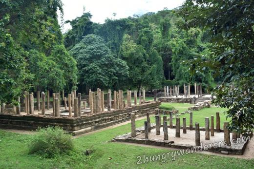
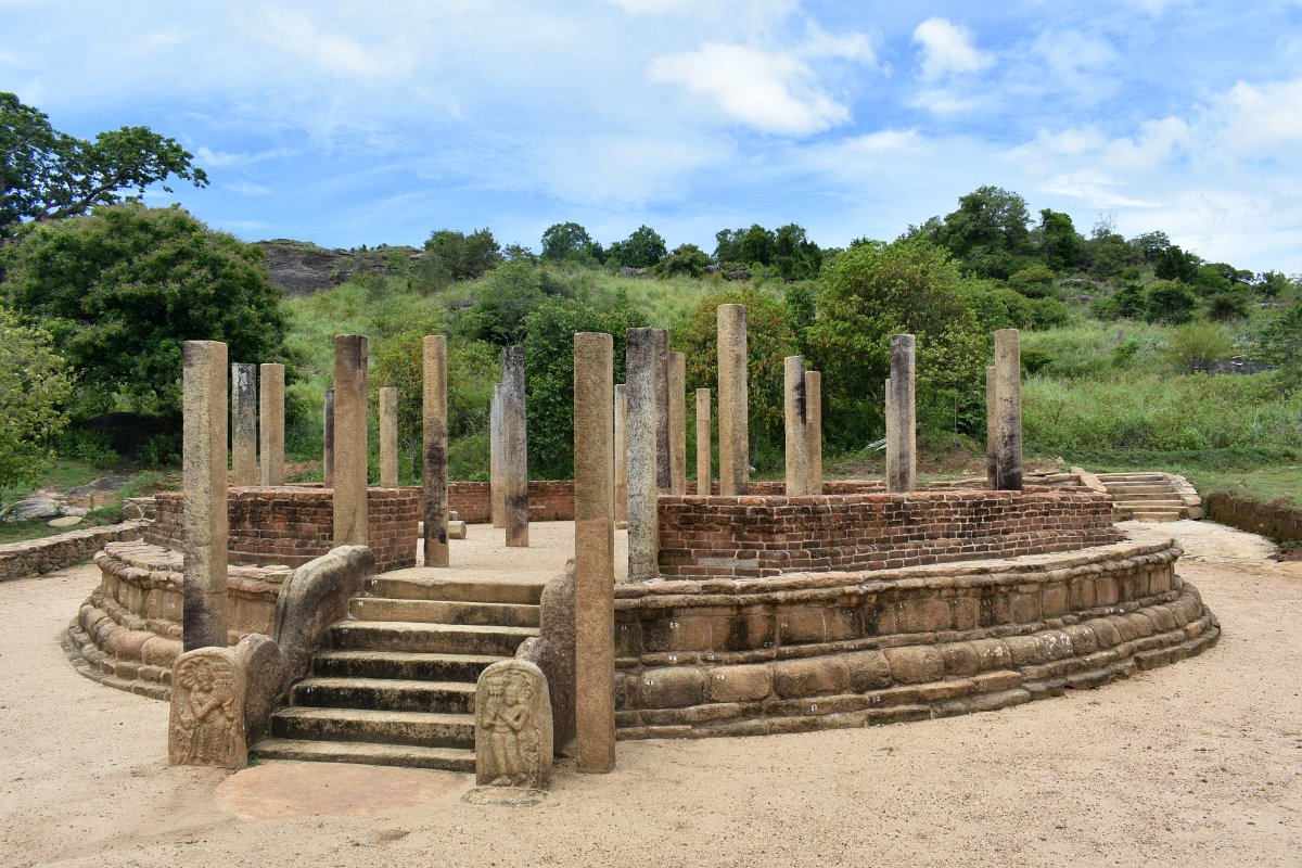
The main zone holds the largest sights and was clearly the center of the monastery complex. A long straight wide path, covered in huge stone plates rolls between the newly unearthed chapter house, refractory, water distribution place and several other buildings.
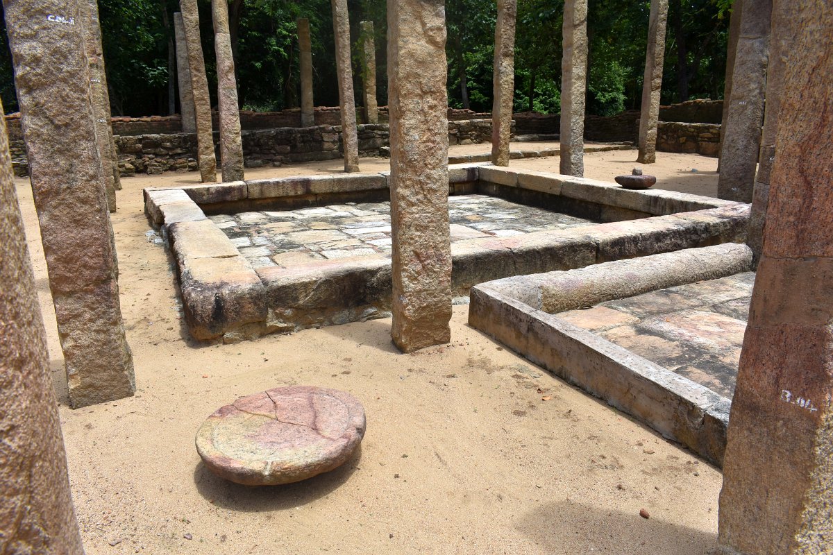
What is thought to be the Chapter house has a small pool in the middle surrounded by columns that used to support a roof.
Next, the Refractory, with its vast hall, says a lot about the size of the monastery that was active for centuries here. It has an unexpected oval form, uncommon for the Sri Lankan architecture of the time.
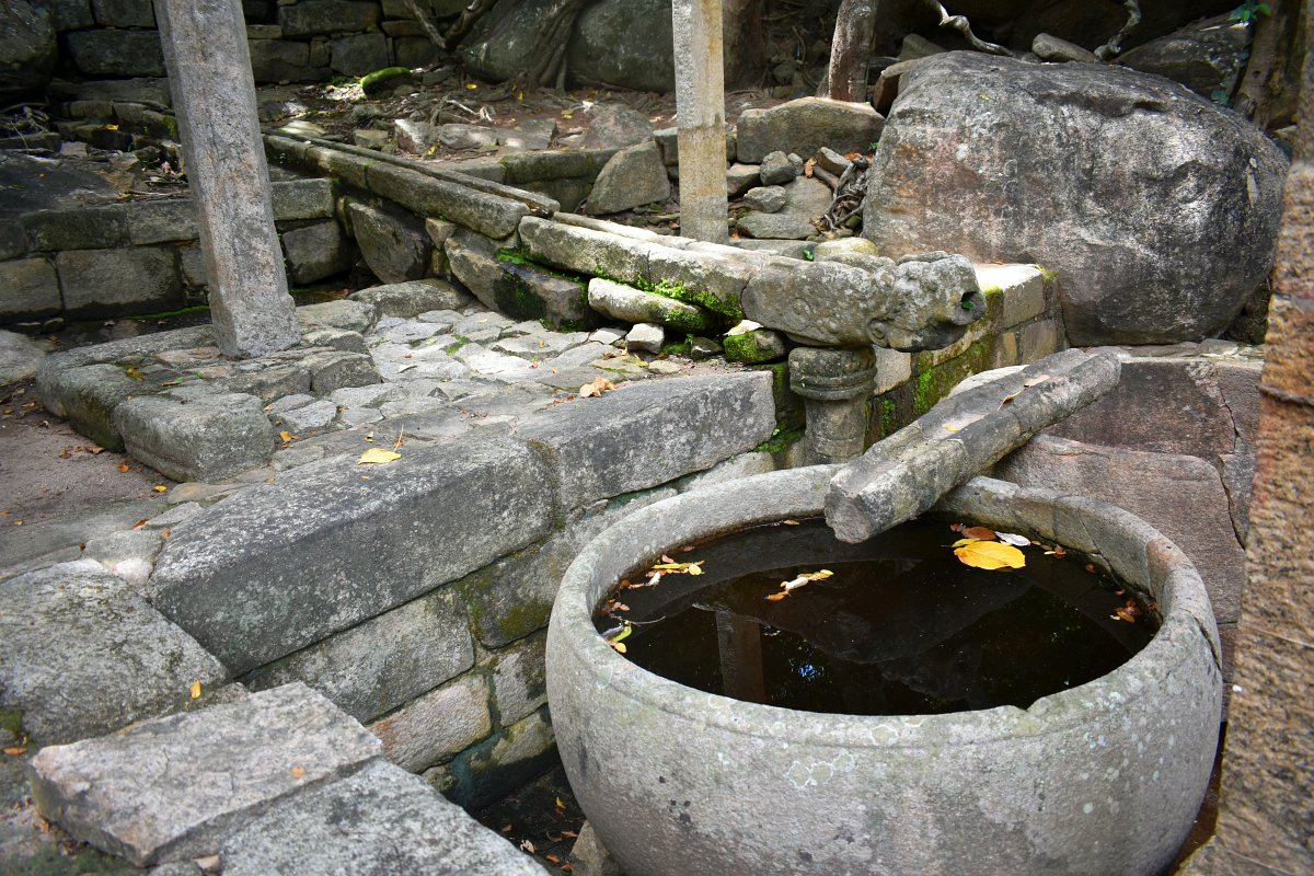
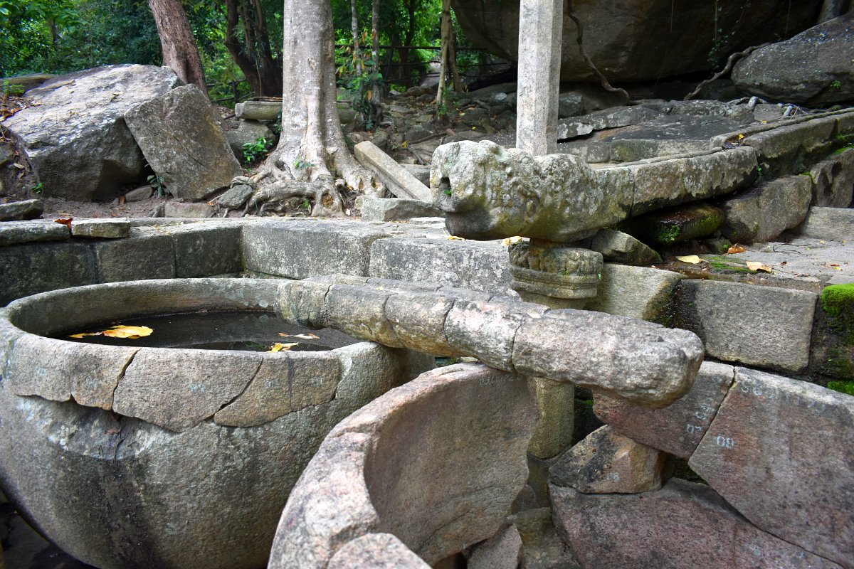
The House of the stone bowls must have been some kind of water distribution place. A stone pipe is coming from the hill above, its end a carved dragon head. The water running through it pours over another stone pipe perpendicular to the first one and then splits the liquid between two huge stone bowls - over a meter in height and around 1.5 m diameter. There are drainage pipes for the excess running out of the building and distributing water around the complex. There are several places where underground canals are visible under the stone paths.
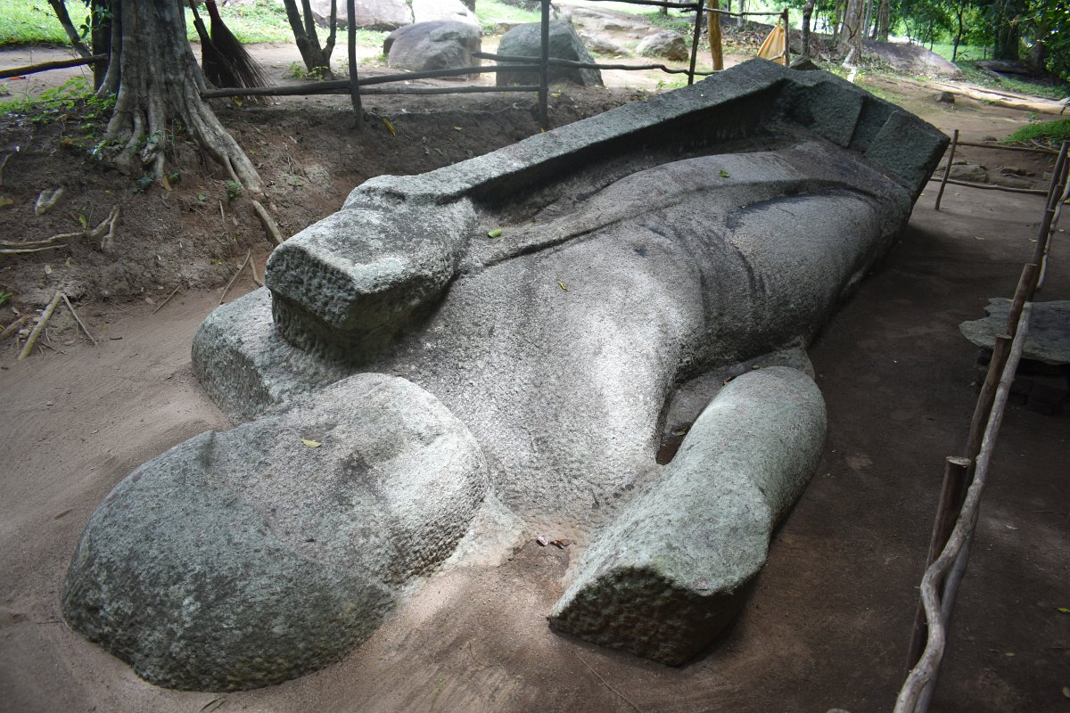
After the Refractory a short stroll on the left leads to an unfinished Buddha statue laying on the ground. For some unknown reason, this tall statue of a standing Buddha was left there, with just a few details missing. It was probably an imperfection in the stone that stopped the craftsmen of the time from completing their task, or it witnessed the end of the monastery itself, abandoned with the rest of the complex.
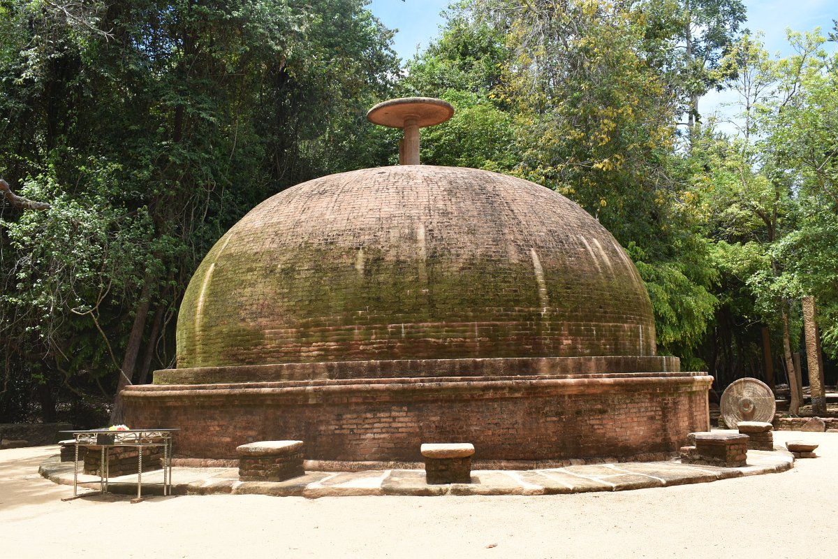
At the end of the main path, there are two big stupas numbered Stupas N1 and N2. The thing to note here is that stupa number 2 has a small stone umbrella on top - an element characteristic of the time, but rarely seen nowadays. The detail is fragile and quickly crumbles down with time, we have seen such stones laying around stupas in other archaeological sites and have read about it in the National Museum in Colombo, but this is the only ancient place we have seen it actually positioned on top of a stupa.
The drip-ledge caves
From this point, a path goes to the right and in the forest and leads to several of the 130 drip-ledge caves sprinkled hidden in the thick jungle.
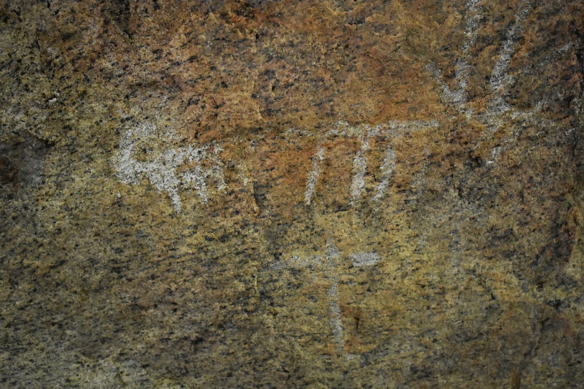
The first one was just at the start of the path and has Vedda paintings - Veddas are the indigenous people of the island and pre-date Buddhism. The petroglyphs are barely visible on the walls, a reminder of forgotten times.
The path goes up and through the forest, a bit narrow in places and not as wide as the previous sections, but still easily followed.
After 10-15 minutes we reached is Shamikha cave - a wide cave with a high drip-ledge. There are stone columns and parts of stone walls still in place, showing that there was a house built-in the niche under the boulders. Here the path forks - right side leading down to the main site and left side leading to several more caves.
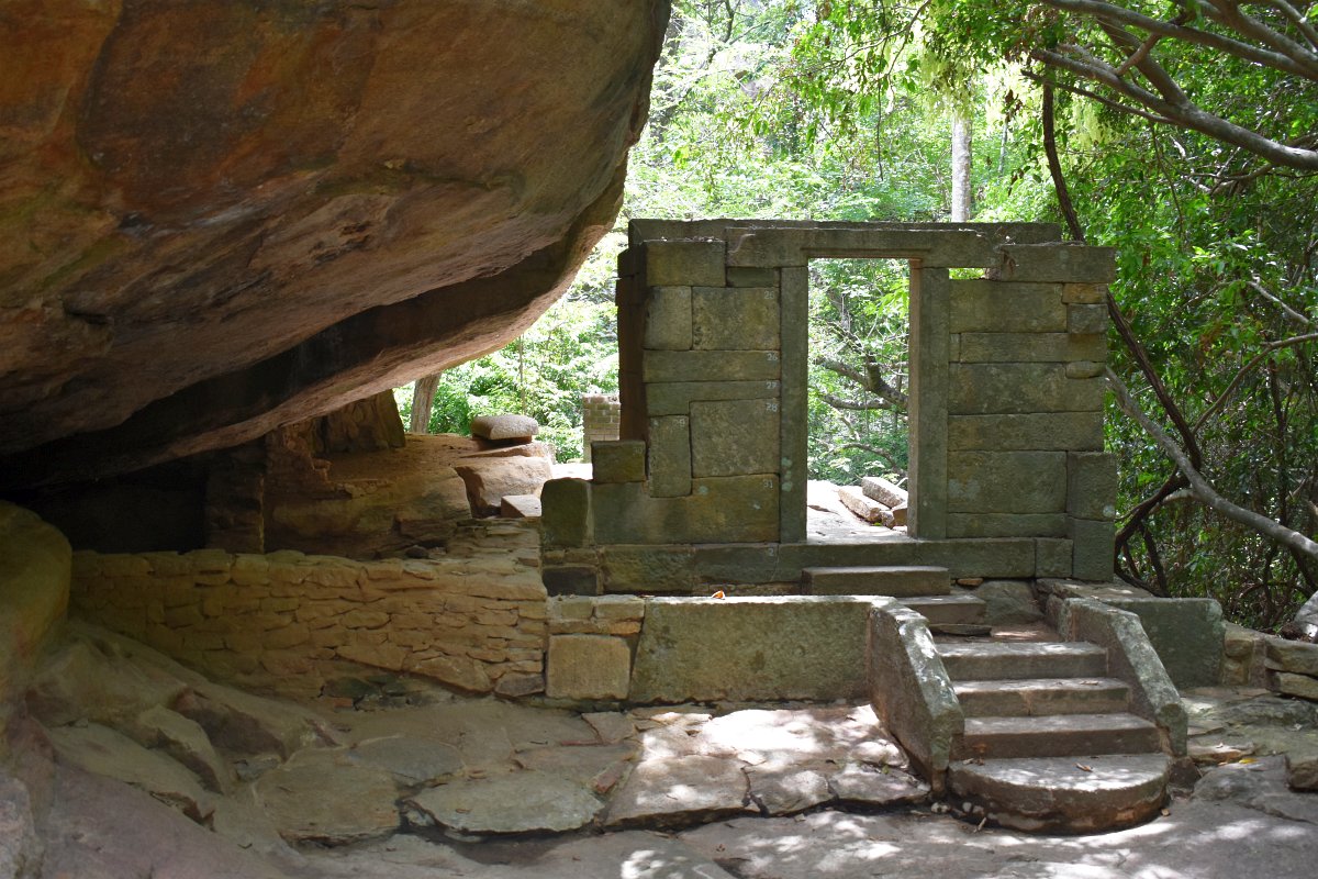
The next cave was the Stone door cave, the name comes from the stone frame of the entrance still standing strong on top of the solid stairs leading up to it. This "cave" must have been a spectacular sight in its time - with tall solid walls and several rooms, including an indoor toilet. The rectangular stones that were once part of the building leaning on huge boulders were scattered around in disarray now.
The path after that cave becomes a little bit harder to follow, we had to carefully look to make sure we are on an actual path and not a random trail in the forest. This might have been because there had been fewer people after the COVID 19 lockdown in the country, or just this part of the route was not visited that often.
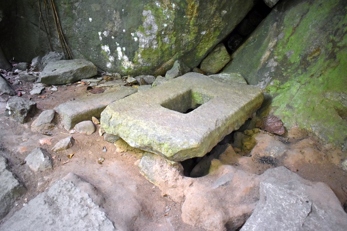
A not so easy to spot trail to the left leads to an ancient toilet stone, the shape surprisingly similar to modern-day squatting toilets.
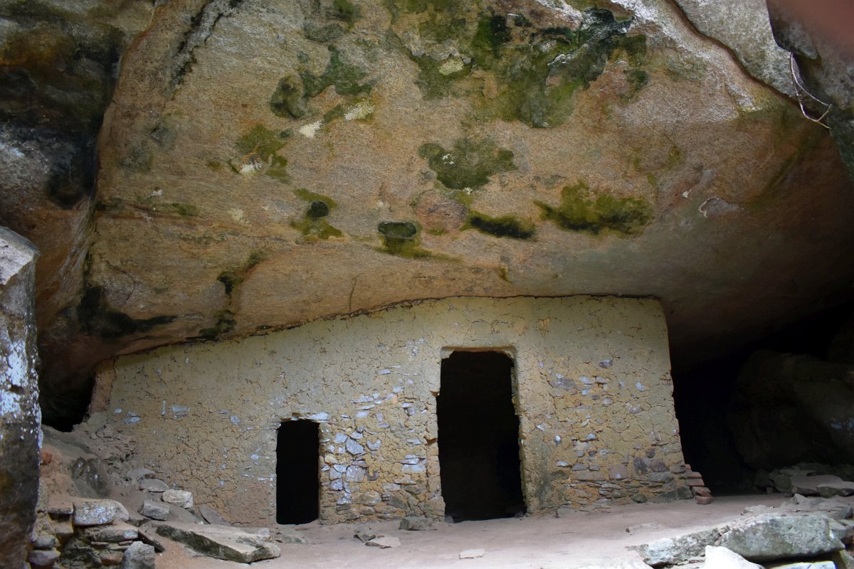
At what seemed the end of the path we found the Cool cave, the name is the original since ancient times, according to an inscription found nearby. The walls of it are still standing and it has two dusty rooms, the air inside not as hot as the outside. The position under the boulders and in the shade of the other rocks around is the reason for the temperature difference.
And here we lost the path. There should be a way to make a full circle, but we just could not find it. Instead of continuing to the other caves nearby - Mahalena and Shiwa Thero caves, plus a handful of unnamed ones, we went back to Shamikha cave and then back down to the House with stone bowls in the main archaeological zone.
Back to the car
There were two possible ways down to the parking lot - the one we came up on along the Southern staircase or a slightly longer one, over the Northern staircase, that goes a bit further to the east. The junction is nearby Mihinda's stupa and having enough time, we chose the long way.
The longer way down is again in the forest, from the fork it goes a little up the hill, then the descent starts. This path seemed newly built, probably with what was left of the original stones, reinforced with concrete. There wasn't much to see on the way down, except for a small pond, probably man-made, considering its proximity to the monastery complex. Near the pond, the path almost disappeared over some exposed rocks, but following the same general direction, soon we were again on the stairs.
A bit hard on the knees, the path winds down to a second parking lot, smaller than the main one, but all ready for the crowds of tourists visiting Rassagala in the future. Another 5-10 minutes and we were at the main parking and got to our car.
All in all, this was an amazing adventure. Started completely unsure of what to expect, Rassagala turned out to be one of the best attractions we visited in Sri Lanka, on par with Mihintale. Very interesting to see the archaeological digs in progress and the many ancient buildings and structures reclaimed from the thick jungle. The lack of crowds, with just a few other enthusiasts except us, made it a very special experience.
Gallery


Comments